Sunday, July 1, 2018

Forest Types of Nepal

Nepal has diverse climatic and topographical features which results in the contribution of different forest types in Nepal.Adapted from J.k. Jackson, here is the list of different forest types of Nepal.


  1. Tropical forest (up to 1000m)


        i.Shorea robusta Forest – The dominant species is Sal and other associates are           Terminalia alata, Anogeissus latifolia, Syzyzium cumini,etc.


ii.Acacia catechu- Dalbergia Sissoo Forest- It is mostly found along streams and rivers in deposited alluvium and often gravelly and will be eventually be succeeded by Sal or other types of forest.


iii. Other Riverain forest- This types of forest is not large and extends far from the stream banks. Jamun is dominant in western Nepal.


iv.Grassland- This type is usually found on poorly drained clays. Grass species such as Saccharam spontaneum, Eulaliopsis bipinata, Phragmites Karka.etc are found.


v.Terminalia- Anogeissus deciduous hill forest- It is confined to dry south facing slopes in the larger river valleys and up to 1200m in Western Nepal.


  1. Sub-Tropical Forest (1000m-1700m in East and 1000m 2000m in West)


i.Pinus roxburghii forest- It is found in the west of Nepal extensively. In the east, it is found in large river valleys. It is almost pure. In the far west at higher altitude, it may be associated with Olea ferruginea, Pistacia spps, etc. In transitional areas, it may be mixed with Schima wallichi or Shorea robusta.


ii.Schima-castanopsis forest – This Schima- castanopsis forest covers very large areas of the mid-hills, but much of it has been cleared for cultivation and very small passages are left.


iii.Alnus nepalensis forest- Alnus nepalensis is dominant and almost pure and associated in some places with Lyonia ovalifolia.


iv.Riverain forest with Toona and Albezia species- It is confined to narrow strips along streams and is very mixed in composition.


  1. Temperate Forest (2000m-3100m)


i.Lower temperate forest ( 2000m- 2700m)


a.Quercus leucotricophora and Quercus lanata


b.Quercus floribunda forest


c.Quercus lamellose forest


d.Lower temperate mixed broad leaved forest with abundant lauraceae


e.Pinus wallichiana forest


ii.Upper temperate forest (2700m – 3100m)


a.Quercus semecarpifolia forest


b.Upper temperate mixed broadleaved forest


c.Rhododendron Forest


d.Upper temperate coniferous forest


4. Sub- Alpine forest (3000m-4200m)

i.Abies spectabilis forest


ii.Betula utilis forest


iii.Rhododendron forest


iv.Juniperous indica steppe


v.Caragana steppe


  1. Alpine forest (up to 4500m)


It has no trees, but shrubby Rhodendrons and Junipers and some other shrubby species are found at lower elevations up to about 4500m.

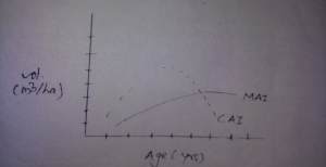
 

What is CAI and MAI?

20180701_065050


CAI is the increment which a tree puts on in a single year. The CAI varies from year to year being affected by seasonal conditions and treatments.


MAI is the mean volume of a tree or crop put on from origin up to the desired age i.e. the total increment up to a given age divided by that age.


If when the curves of Current and Mean annual increments are plotted over tree age, the two do not coincide with each other through out the life of the tree except at two periods one at the end of first year and the other at the culmination of MAI.The CAI rises to maximum and then gradually fall off.The MAI also increases to a maximum at a later age but with much lower rate.The MAI continues to rise towards maximum even after the CAI has started falling. 


When the CAI falls to such an extent it is equal to MAI, the MAI reaches its highest points. This is the year of culmination of the MAI. At later stage, the CAI is less than the MAI, and MAI also beings to drop but not as rapid as that of CAI. THE CAI will be zero and also negative when there is rot or other damages resulting in negative CAI. But the  MAI value is never Zero and negative like CAI.


What is DBH ?

DBH is defined as the average stem diameter outside bark at the point of 1.3m or 1.37m (FAO) above the ground as measured.

  • It is a convenient height for taking measurement as it does not require bending down or stretching up to reach a lower or higher point.

  • It is a place on a tree stem, which is free from obstructions from thorny shrubs  and abnormalities like root swell, etc.

  • It gives uniform point of measurement and therefore standardizes measurement.

  • It shows strong correlation to the volume or weight of the stem for most tree species.

Rules of the DBH Measurement


  • Loose barks, mosses, lichens that are found on the tree must be removed before measuring the diameter over bark.

  • Breast Height (BH) should be measured by means of a measuring stick on standing trees at 1.3m or 1.37m (FAO)  above the ground level.

  • BH should be marked by intersecting vertical and horizontal lines 12 cm long painted with white paint.

  • On sloping land, the diameter at BH should be measured on uphill side.

  • In case of the tree is leaning, DBH is measured along the tree stem and not vertically, on the side of the lean for trees growing on flat ground and on uphill side, for trees growing on sloping ground.

  • BH should be taken at the lowest point above which the buttress formation is not likely to extend.

  • When the tree is forked above the BH, it is counted as one tree, but when it is forked below BH, each fork should be treated as though it were a separate tree.